


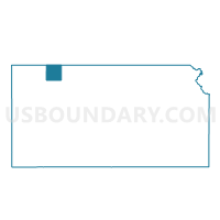
Sappa Township Voting District, Decatur County, Kansas
About
Outline

Summary
| Unique Area Identifier | 584462 |
| Name | Sappa Township Voting District |
| County | Decatur County |
| State | Kansas |
| Area (square miles) | 36.01 |
| Land Area (square miles) | 35.99 |
| Water Area (square miles) | 0.01 |
| % of Land Area | 99.96 |
| % of Water Area | 0.04 |
| Latitude of the Internal Point | 39.79464140 |
| Longtitude of the Internal Point | -100.68555220 |
Maps

Graphs
Select a template below for downloading or customizing gragh for Sappa Township Voting District, Decatur County, Kansas


Neighbors
Neighoring Voting District (by Name) Neighboring Voting District on the Map
- Bassettville Township Voting District, Decatur County, KS
- Herl Township Voting District, Rawlins County, KS
- Liberty Township Voting District, Decatur County, KS
- Logan Township Voting District, Decatur County, KS
- Oberlin Township Voting District, Decatur County, KS
- Summit Township Voting District, Decatur County, KS
Top 10 Neighboring County Subdivision (by Population) Neighboring County Subdivision on the Map
- Herl township, Rawlins County, KS (310)
- Oberlin township, Decatur County, KS (81)
- Liberty township, Decatur County, KS (51)
- Sappa township, Decatur County, KS (36)
- Bassettville township, Decatur County, KS (35)
- Logan township, Decatur County, KS (33)
- Summit township, Decatur County, KS (13)
Top 10 Neighboring Unified School District (by Population) Neighboring Unified School District on the Map
- Oberlin Unified School District 294, KS (2,808)
- Rawlins County Unified School District 105, KS (2,108)